7 Days Kilimanjaro Lemosho Route is a 7 Days trekking itinerary on Kilimanjaro via the Lemosho route. It is designed for travelers who want a serious mountain experience with a clear day-by-day structure, sensible altitude gain, and support from an experienced crew rather than a rushed ascent.
What makes this route effective is how the terrain changes as you climb. Forest gives way to moorland, alpine desert, and finally the upper summit zone, so the trek feels progressive both physically and visually. Each stage has its own rhythm, and that steady progression is a major part of the experience.
The itinerary is paced to balance walking effort, rest, and acclimatization. Camp or hut stops are not simply overnight points; they are part of how the route prepares you for the summit push, especially on the longest climbing days and the final ascent window.
This route suits trekkers who value preparation, patience, and a realistic mountain plan. You do not need technical climbing skills for these climbs, but you do need endurance, a calm pace at altitude, and the discipline to treat acclimatization as seriously as the summit itself.
7 Days Kilimanjaro Lemosho Route leads you up the mountain stage by stage — each day a new altitude, a new ecological zone, and a measured step toward the summit.
-
1
Day 1: Drive to Kilimanjaro Londorossi Gate, Hike to Mti Mkubwa Camp
Altitude 1830m/6000ft to 2650m/8700ft Distance 6km/4mi Hiking 2-3 hours Habitat Montane ForestAfter breakfast and briefing, drive to Londorossi Park Gate (about a 2.5-hour drive). From here a forest track requiring a 4WD vehicle leads to Lemosho Glades.
Walk along forest trails to Mti Mkubwa (big tree) campsite.
Elevation: 1830m/6000ft to 2650m/8700ft
Distance: 6km/4mi
Hiking Time: 2-3 hours
Habitat: Montane ForestMeals included: Lunch, Dinner Budget Accommodations: Mti Mkubwa Camp
Mti Mkubwa CampOvernight camp -
2
Day 2: Hike Mti Mkubwa Camp to Shira 2 Camp
Altitude 2650m/8700ft to 3850m/12,600ft Distance 16km/10mi Hiking 7-8 hours Habitat MoorlandAfter breakfast, we continue as the trail gradually steepens and enters the giant heather moorland zone. After several streams are crossed we continue over the Shira Ridge past the Shira 1 camp and on to the Shira 2 camp on moorland meadows by a stream.
Elevation: 2650m/8700ft to 3850m/12,600ft
Distance: 16km/10mi
Hiking Time: 7-8 hours
Habitat: MoorlandMeals included: Breakfast, Lunch, Dinner Budget Accommodations: Shira 2 Camp
Shira 2 CampOvernight camp -
3
Day 3: Hike Shira 2 Camp to Barranco Camp
Altitude 3850m/12,600ft to 4000m/13,000ft Distance 8km/5mi Hiking 5-6 hours Habitat Semi-desertFrom the Shira Plateau, we continue to the east up a ridge, passing the junction towards the peak of Kibo. As we continue, our direction changes to the South East towards the Lava Tower, called the “Shark’s Tooth” (elev 4650m/15,250ft).
Shortly after the tower we come to the second junction which goes to the Arrow Glacier. We now continue down to the Barranco Camp.
Although you end the day around the same elevation as when you began, this day is very important for acclimatization and will help your body prepare for summit day.
Elevation: 3850m/12,600ft to 4000m/13,000ft
Distance: 8km/5mi
Walking Time: 5-6 hours
Habitat: Semi-desertMeals included: Breakfast, Lunch, Dinner Budget Accommodations: Barranco Camp
Barranco CampOvernight camp -
4
Day 4: Hike Barranco Camp to Karanga Camp
Altitude 4000m/13,000ft to 4050m/13,250ft Distance 5km/3mi Hiking 34 hours Habitat Alpine DesertAfter breakfast, we leave Barranco and continue on a steep ridge up the Barranco Wall to the Karanga Valley and the junction which connects with the Mweka Trail.
Elevation: 4000m/13,000ft to 4050m/13,250ft
Distance: 5km/3mi
Hiking Time: 34 hours
Habitat: Alpine DesertMeals included: Breakfast, Lunch, Dinner Budget Accommodations: Karanga Valley Camp
Karanga Valley CampOvernight camp -
5
Day 5: Hike Karanga Camp to Barafu Camp
Altitude 4050m/13,250ft to 4700m/15,350ft Distance 4km/2mi Hiking 3-4 hours Habitat Alpine DesertWe continue up to the Barafu Camp. You have completed the South Circuit, which offers views of the summit from many different angles.
Here we make camp, rest, enjoy dinner, and prepare for the summit day.
Elevation: 4050m/13,250ft to 4700m/15,350ft
Distance: 4km/2mi
Hiking Time: 3-4 hours
Habitat: Alpine DesertMeals included: Breakfast, Lunch, Dinner Budget Accommodations: Barafu Camp
Barafu CampOvernight camp -
6
Day 6: Hike Barafu Camp to Summit, down to Mweka Camp
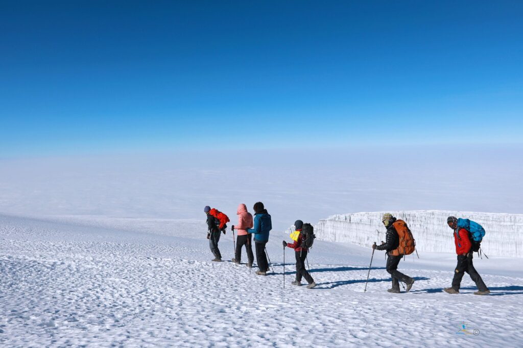
Altitude 4700m/15,350ft to 5895m/19,340ft Distance 5km/3mi up / 13km/8mi down Hiking 5-7 hours up / 5-6 hours down Habitat Stone scree and ice-capped summitVery early in the morning (midnight to 2 am), we continue our way to the summit between the Rebmann and Ratzel glaciers. You head in a northwesterly direction and ascend through heavy scree towards Stella Point on the crater rim.
This is the most mentally and physically challenging portion of the trek. At Stella Point you will stop for a short rest and will be rewarded with the most magnificent sunrise you are ever likely to see.
Faster hikers may view the sunrise from the summit. From Stella Point, you may encounter snow all the way on your 1-hour ascent to the summit.
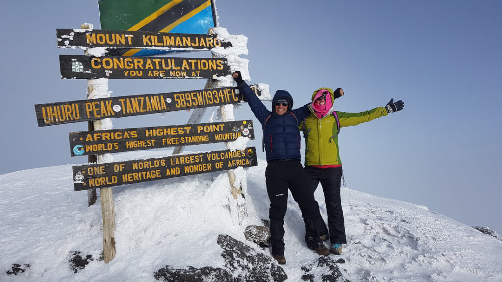
Once at Uhuru Peak you have reached the highest point on Mount Kilimanjaro and the continent of Africa! From the summit we begin our descent by continuing straight down to the Mweka Camp, stopping at Barafu for lunch.
You may want gaiters and trekking poles for the loose gravel going down. We arrive at Mweka Camp and enjoy our last evening on the mountain.
Down to 3090m/10,150ft
Elevation: 4700m/15,350ft to 5895m/19,340ft
Distance: 5km/3mi up / 13km/8mi down
Hiking Time: 5-7 hours up / 5-6 hours down
Habitat: Stone scree and ice-capped summitMeals included: Breakfast, Lunch, Dinner Budget Accommodations:
-
7
Day 7: Hike Mweka Camp to Mweka Gate, drive to Arusha city
Altitude 3090m/10,150ft to 1680m/5500ft Distance 10km/6mi Hiking 3-4 hours Habitat ForestAfter breakfast, we continue the descent down to the Mweka Park Gate to receive your summit certificates. At lower elevations, it can be wet and muddy.
Gaiters and trekking poles will help. Shorts and t-shirts will probably be plenty to wear (keep rain gear and warmer clothing handy).
From the gate, continue another hour to Mweka Village. A vehicle will meet you at Mweka village to drive you back to your hotel in Arusha city (about 30 minutes).
Don’t forget to tip your guides and porters.
Elevation: 3090m/10,150ft to 1680m/5500ft
Distance: 10km/6mi
Hiking Time: 3-4 hours
Habitat: ForestMeals included: Breakfast Price inclusive
All prices are per person. Final rates vary with route length, group size, and any safari or hotel extensions you add before or after the climb.
- – All park, conservation, camping, and rescue fees required for the route
- – Professional mountain guide, assistant guides, cook, and porter support
- – Private transfers between your hotel and the trek gate as listed in the itinerary
- – All meals on the mountain plus safe drinking water during the climb
- – Mountain tents, dining tent, table, chairs, and standard camping equipment
- – Emergency oxygen, basic first-aid kit, and daily health monitoring on the mountain
Are You Ready for the Climb?
This 7 days reaches high altitude and should be approached with steady pacing, hydration, and realistic fitness preparation. The route climbs to 5,895 m · Uhuru Peak, so altitude response matters more than speed. A longer, calmer ascent usually improves comfort and summit chances, especially when you listen closely to your mountain crew and allow time for acclimatization. Trekkers do not need technical climbing skills for Kilimanjaro, but they do need endurance for long walking days and summit night effort.
Recommended Gear Checklist
- Waterproof hiking boots · Essential
- Layered warm clothing for summit night · Essential
- Waterproof jacket and rain trousers · Essential
- Daypack and duffel bag · Essential
- Headlamp with spare batteries · Essential
- Sun hat, sunglasses, and sunscreen · Essential
- Trekking poles
- Refillable water bottles or hydration bladder · Essential
-
How difficult is the Lemosho?
This route is best described as challenging. The main challenge is sustained trekking at altitude rather than technical climbing.
-
How many days should I allow for this trek?
This itinerary is planned over 7 Days, giving a clear stage-by-stage progression through the mountain route shown in the itinerary.
-
Do I sleep in huts or tents on this route?
This route uses mountain tents according to the imported itinerary and overnight camp references.
-
When is the best season to climb?
The usual best climbing windows are Jan–Mar, Jun–Oct, when trail conditions are generally more favorable and mountain visibility is often better.
-
What helps summit success on this route?
This route is known for high on the longer itinerary. The biggest factors remain pacing, hydration, rest, and allowing the body time to adapt to altitude.
Photo gallery will be added soon.